iNoise®
Noise Prediction for Road, Rail,
Industry and Wind Turbines
 Noise Prediction for Road, Rail, Industry and Wind Turbines
iNoise is intuitive and quality assured software for noise calculations in the environment. The calculations are based on the ISO 9613 and CNOSSOS-EU methods and the recommendations of the quality standard ISO 17534. The GUI is based on the Windows design rules for a genuine Windows user experience.
Why iNoise?
- For road, rail, industry and wind turbines
Sound power databases included - Free, Pro and Company licenses
Free license included in setup - Subscription based solution
reduces your initial investment - Easy to use
Intuitive, getting started tutorial included - Easy to install
no hardware dongle needed - Quality assured software
full support of ISO 17534 QA standard - QSI format support for exchange of model data with other noise prediction software
- Trusted software, in use by thousands
- iNoise Cloud Calculation Service frees up your computer for more efficient, flexible work.

Quality assured software
The CNOSSOS-EU and ISO 9613 standard are among the most used noise prediction method worldwide. Many countries refer to these standards in their noise legislation. However the standards do not contain guidelines for quality assured software implementation, which leads to differences between applications in calculated results. In 2015 this changed with the release of ISO/TR 17534. This quality standard gives clear recommendations for interpreting the methods. iNoise fully supports these recommendations. The models and results for the test cases are included in the software.
iNoise supports the quality assurance interface (QSI format) for exchanging model data with other noise prediction software.
I found it really easy to get to know the program using the ‘Getting Started’ guide. I found the menu’s and functions very intuitive. I typically found that when I thought a function should exist, it did and it was where I expected it to be.
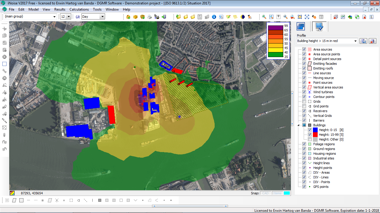
Advanced import, editing and result display
File formats: SHP/DXF/DWG/GDB/GPKG/GML/GMF/MIF/TXT, QSI/TIFF/BMP/JPG/PNG/WMF, WMS (Web Map Services), WMTS Edit: 2D/3D/cross section, thematic display, copy/paste, paste as other item, undo/redo, snap/move/rotate/rescale, parallel items, break/connect/merge/clip/simplify polylines and polygons. Results: horizontal/vertical (façade)/cumulated/difference contours, ranking/what if/compare models.
Advanced modelling items
Sources: road, railway, point/line/area source, vertical area source, moving source, wind turbine, emitting façade/roof. Objects: (floating) building, (floating) barrier (with transmission), ground/foliage/housing region, industrial site, crossing, roundabout. Terrain model: height line, height point. Calculation point items: receiver (with up to 5 heights), horizontal grid, vertical grid, contour point (for irregular grids)